Lake Powell is a reservoir on the Colorado River, straddling the border between Utah and Arizona. It is a major vacation spot that around 2 million people visit every year. It is the second largest man-made reservoir by maximum water capacity in the United States behind Lake Mead, storing 24,322,000 acre feet of water when full. However, due to high water withdrawals for human and agricultural consumption, and because of subsequent droughts in the area, Lake Powell is currently larger than Mead in terms of volume of water currently held, depth and surface area. Lake Powell was created by the flooding of Glen Canyon by the Glen Canyon Dam, which also led to the creation of Glen Canyon National Recreation Area, a popular summer destination. The reservoir is named for explorer John Wesley Powell, a one-armed American Civil War veteran who explored the river via three wooden boats in 1869.
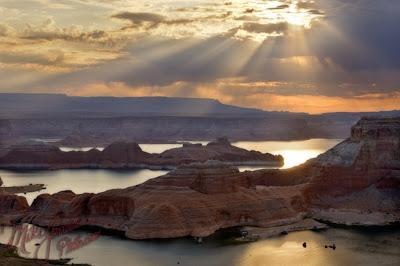 In 1972, Glen Canyon National Recreation Area was established. It is public land managed by the National Park Service, and available to the public for recreational purposes. It lies in parts of Garfield, Kane, and San Juan counties in southern Utah, and Coconino County in northern Arizona. The northern limits of the lake extend at least as far as the Hite Crossing Bridge. A map centered at the confluence of the Escalante River with the Colorado River gives a good view of the extent of the lake. Lake Powell is a water storage facility for the Upper Basin states of the Colorado River Compact (Colorado, Utah, Wyoming, and New Mexico). The Compact specifies that the Upper Basin states are to provide a minimum annual flow of 7,500,000 acre feet (9.3 km3) to the Lower Basin states (Arizona, Nevada, and California).
 The major feature of the park is Bryce Canyon, which despite its name, is not a canyon, but a collection of giant natural amphitheaters along the eastern side of the Paunsaugunt Plateau. Bryce is distinctive due to geological structures called hoodoos, formed by frost weathering and stream erosion of the river and lake bed sedimentary rocks. The red, orange, and white colors of the rocks provide spectacular views for park visitors. Bryce sits at a much higher elevation than nearby Zion National Park. The rim at Bryce varies from 8,000 to 9,000 feet (2,400 to 2,700 m).
 The park is located on the Colorado River 4 miles (6 km) north of Moab, Utah. It is known for containing over 2,000 natural sandstone arches, including the world-famous Delicate Arch, in addition to a variety of unique geological resources and formations. The park is located just outside Moab, Utah, and is 76,679 acres (119.811 sq mi; 31,031 ha; 310.31 km2) in area.[3] Its highest elevation is 5,653 feet (1,723 m) at Elephant Butte, and its lowest elevation is 4,085 feet (1,245 m) at the visitor center. Forty-three arches are known to have collapsed since 1977. The park receives 10 inches (250 mm) of rain a year on average. Administered by the National Park Service, the area was originally named a National Monument on April 12, 1929. It was redesignated as a National Park on November 12, 1971.